Enregistrez gratuitement cette image
en 800 pixels pour usage maquette
(click droit, Enregistrer l'image sous...)
|
|
Réf : T01350
Thème :
Terre vue de l'espace - Villes (375 images)
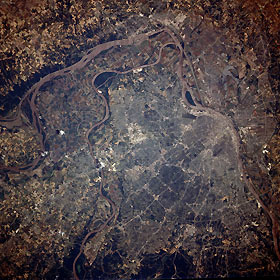
Titre : Saint Louis, Missouri, U.S.A. June 1991
Description : (La description de cette image n'existe qu'en anglais)
The Saint Louis metropolitan area, the Mississippi River, and the Missouri River are prominent in this near-vertical-looking photograph. The runways of Saint Louis Lambert International Airport are pictured near the center of the photograph, while agricultural field patterns surround the metropolitan area and are especially pronounced in the floodplains of the Mississippi and Missouri Rivers north of the city. This photograph was taken before the devastating floods that occurred in the spring and summer of 1993. Major features perceptible in this photograph include numerous major highway systems and interchanges traversing the city; bridges crossing both the Mississippi River and the Missouri River; and oxbow-shaped Horseshoe Lake in Illinois, east of downtown Saint Louis. The Saint Louis area, a major commercial and industrial center, was famous in the 19th century as a major inland port and supply center. The city was considered the Gateway to the West for pioneers intent on settling lands west of the Mississippi and Missouri Rivers.
|
|

